

- admin529303
Land Slips and Slip Surveys
Updated: Nov 24, 2023
Buckton Surveyors and Planners have done lots of Slip Surveys helping with cleanup after the unfortunate recent events in 2023.
The unfortunate weather of 2023 caused flooding and land slips leading to a large amount of damage to private property and our public infrastructure. It has been a long cleanup. Some of the damage can be tidied up by contractors without any surveying or engineering input. More serious slips require a Slip survey, engineering design, and remedial works.

What We’re Up To
Slip Surveys From Warkworth to West Auckland


Buckton Surveyors and Planners were proud to be involved in the efforts to repair the damage. From helping a Warkworth local just a few hundred metres from our main office to spending days in Piha where the damage was more serious.
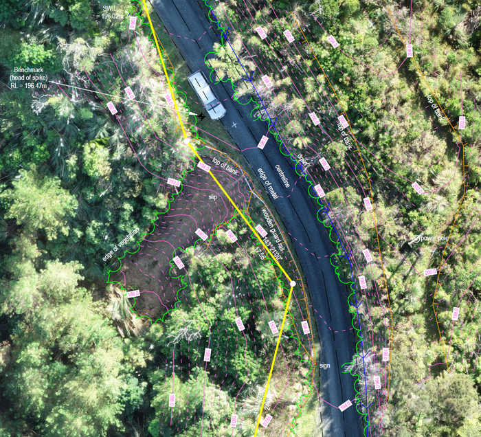
Our Slip survey datasets are a combination of conventional survey measurements (GPS and total station) together with UAV data. The UAV photo clearly shows the slip extents in relation to site features. The UAV data can also be used to create a 3D surface of the slip face. Not only does this speed up the survey, but it also means our field crew can completely avoid walking on the steep and dangerous faces. On all Slip surveys, we combine this modern technology with the old-school surveying techniques of boundary definition. This ensures we are providing a dataset where the boundaries are accurately defined, and the extent of the slip on each property is correctly shown.
Get in touch with us
0800 buckton
16 Mill Lane, Warkworth, Auckland